August 23rd, 2018.
Day 6.
I was up early. 4:30 a.m. local.
I downloaded all my videos and photos from the day before and began checking my maps for the day ahead.
Today the plan was to make it to places that I had been waiting most of my teenage and adult life to get the chance to visit - Monument Valley and The Grand Canyon!
Some rain and thunderstorms were in the forecast for the area today, but hopefully I would dodge them as I was heading westwards away from them.
Around 5:30 a.m. I began loading up the bike in anticipation of the ride ahead.
I opted for a pretty heavy breakfast, stopping by the McDonalds establishment almost next door to the motel.
As I downed my Egg McMuffin and a cup of coffee, the manager came over and chatted with me briefly.
A fellow biker, he was curious/interested in my journey. ( He rides a Kawasaki Twin/cruiser) and looks forward to the day when he will embark on a journey of this kind for himself.
A true gentleman, he was kind enough to let me fill up my Yeti insulated cup with ice.
The day promised to to be hot further west.
So after fueling up for the day at the gas station next door to McDonalds, I was on the road at 8:30 a.m., having started my journey for the day.
US 64 filtered me along and into the town of Teec Nos Pos, AZ where I turned northwards onto US 160 and then on towards the “Four Corners” Monument.
(In case I haven’t mentioned it already, Four Corners is the geographical location in America where 4 separate states all come together and meet - New Mexico, Arizona, Utah and Colorado).
What gorgeous scenery!
What natural beauty to behold!
I could not ride without stopping every couple of miles or less without stopping to take photos!
I was burning up a lot of time. By midday I had only covered 67 mi. (107 km)!
The road cut across the desert landscape, taking me past rock formations which I have no words to describe, so you will have to rely on some of my photos due to my shortcomings.
I soon arrived at “Four Corners, mingled with the multitude of tourists and waited for my turn to take a photo on the spot.
Begging a fellow elderly lady tourist to take a photo of me, she obliged me without hesitation.
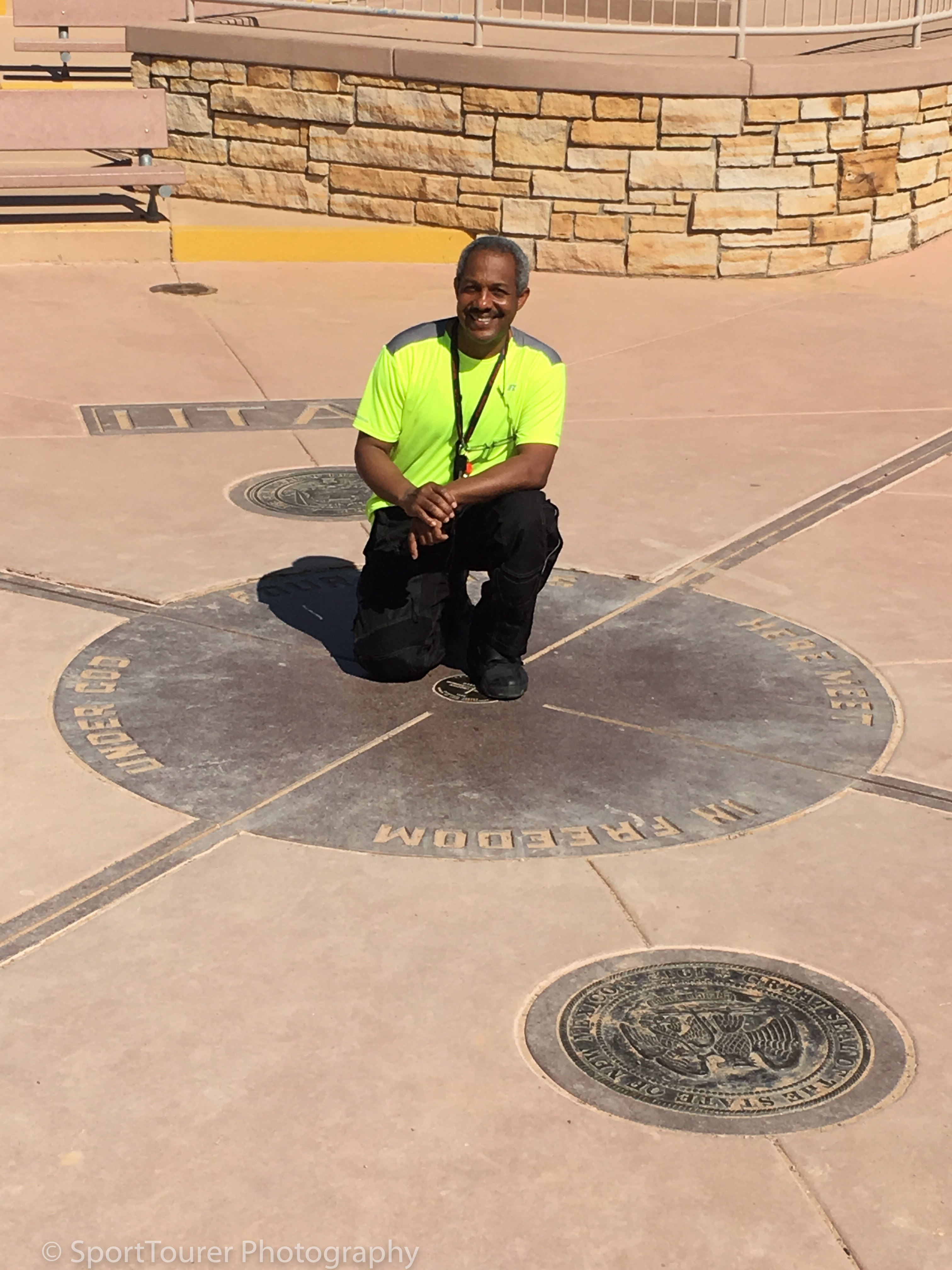
If you find yourself in this area and at this spot, please know that this area is surrounded completely by Indian (Native American) lands. The Navajo Nation lies within New Mexico, Arizona and Utah. The Ute Mountain and Ute Nation is located in Colrado, so please respect their culture and traditions.
So having now visited this monument/marker and checking it off on my bucket list, I resumed my journey northwards towards Bluff, UT along highways 41 and 162.
I was thoroughly amazed at the scenery, feeling so minuscule amongst the giant rock formations and vastness of the area.
The road, bike and I were swallowed up without a fuss, all the way till we came to the junction of highway 162 and US highway 191 - the town of Bluff, UT. I was met by rock formations, again, too grand to describe, but particular note I can make of a pair of almost identical rock formations known as Twin Rocks.
Staying on US 163, I continued to be amazed and wowed by the nature of the land I was riding through. This was so unique!
I plowed on for miles, gawking at the different colors and formations of rock, oblivious to the heat of the day and not wanting this ride to ever end.
The bike and I “carved the canyons” and eventually arrived at the Mexican Hat monument (see it in the photo album as well).
I took time off the road and went down a gravel/rocky road for a much closer view/experience of it.
Needless to mention, the town of this area is aptly named - Mexican Hat.
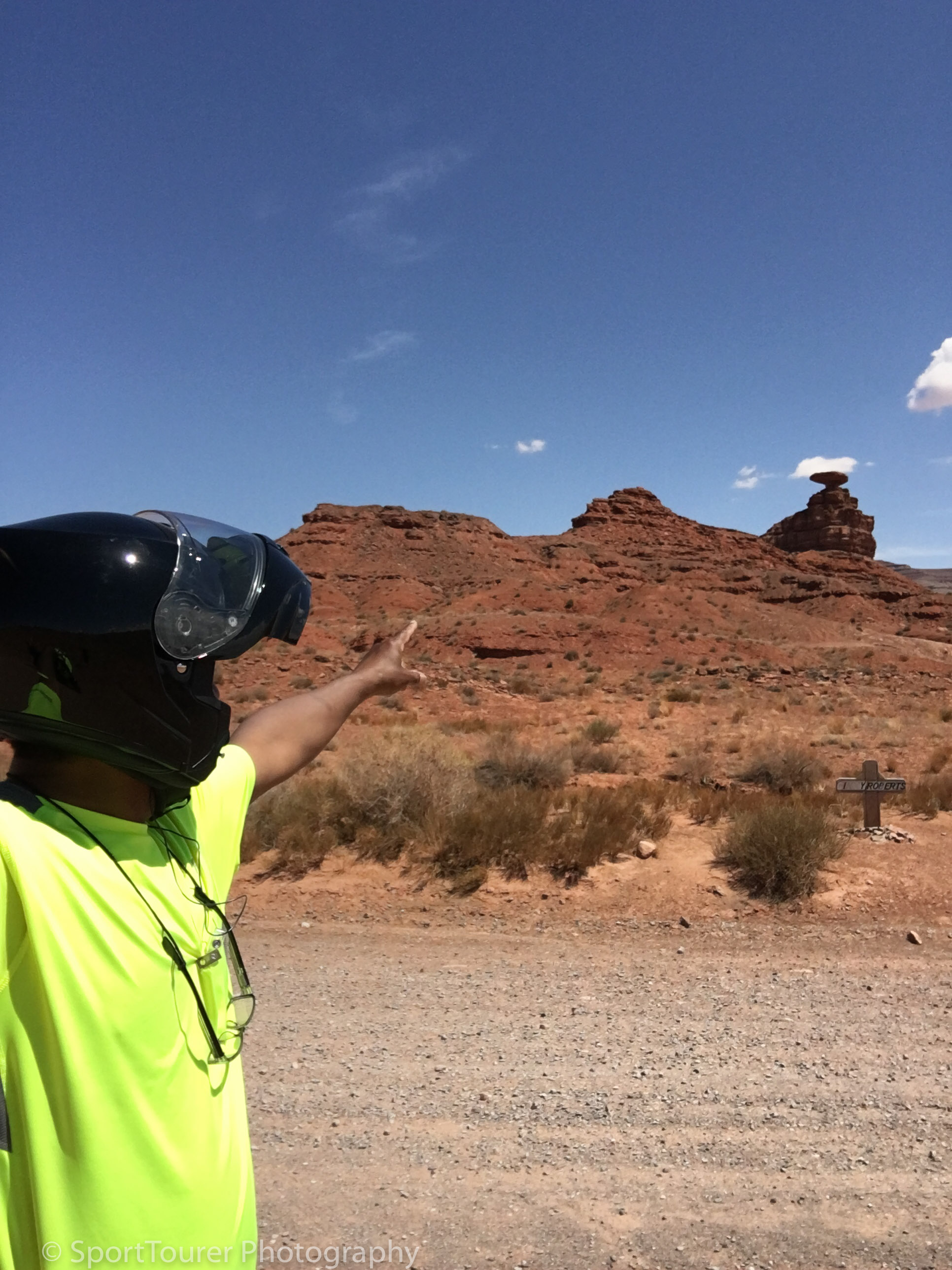
I was alone here. No one else in sight. It was so serene. I took a few photos and continued my journey into the town close by, named - yes, you guessed it - Mexican Hat.
It was a good opportunity to get some much needed fuel and to take a mandatory break off the road to rehydrate and have some snacks.
I found a gas station not too far down the way and used the chance for fluids but could not find any shade in a public place, short of staying underneath the rood of the pump island of the gas station.
I took the liberty and downed a can of Pepsi and a Hershey chocolate bar for the much needed calories, many of which I had no doubt burned up in the last several hours.
The day had seriously heated up. It was around 2 in the afternoon - local time, with no sign of cooling down anytime soon.
What did I expect?
I was in the middle of a desert in the far western reaches of America, in the month of August!
Soon I was back on the road again, now heading due south towards Oljato-Monument Valley.
The Oljato-Monument Valley straddles the Utah and Arizona states and has, for decades, been the source of inspiration for the movie settings of directors like John Ford, famous for the Western Movies Genre he has entertained us with about stories and legends of the old west.
This place has been made so famous to us by him that It undoubtedly invokes images of what I envision the old west was/used to be like.
Coming over a rise in the road, I was atop an elevated area when I caught my first glimpse of Monument Valley waaaaaaay of in the distance.
I stopped for a photo op to immortalize my moment of sheer joy.
I had made it here. I had gotten my first glimpse of a place I had so long dreamed of and had seen so many times in movies, that made me feel a certain kind of familiarity and connection with the place.
I motored on and followed the dip of the road.
Then it disappeared from view!
I rode for what seemed to be an eternity before it came into view again. I was still far off, being deceived by the vastness of the area. But with each minute, I was getting closer and closer, till eventually I arrived at the foothills.
I was mesmerized.
Nothing can prepare you for the sheer size and grandeur of this monument.
I pulled off the road, parked the bike, stood at the side of the road and just gawked at the view I was witnessing first hand!
Good time to have lunch.
Reaching into my bag, I took out my “buffalo wings” (left overs from my last dinner at James and Mary’s in OKC) and reached for a bottle of Gatorade.
No better place for me to have lunch than right here by the iconic monuments of the world-famous Monument Valley!
I took my time.
It had definitely been worth the trip so far!
All too soon, I needed to leave. This place I realized was large (that is an understatement) and this late in the day I would have to really lay some miles down quickly in order to make it to my next destination - The Grand Canyon - before too late in the day.
I arrived in Kayenta at the junction of US 163 and US 162 and made a right turn towards Tsegi, AZ.
Beautiful road. Lovely asphalt. Not a ripple or bump in it. Oh what a smooth ride it provided.
Off in the distance I could make out the tell-tale signs of a pending rainstorm.
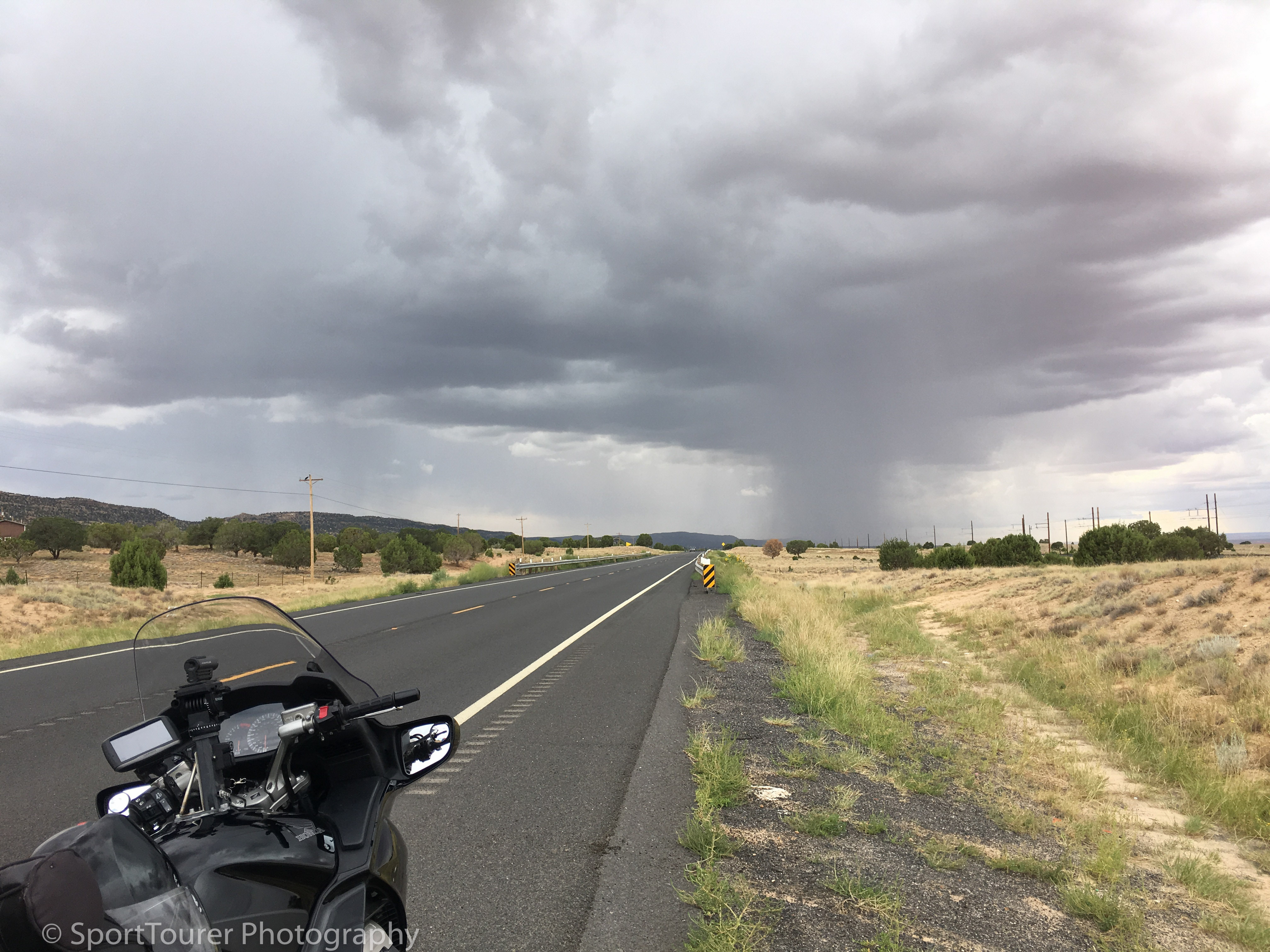
I pulled over for a quick and necessary potty break whilst anticipating the rainstorm.
It was obvious that the rain would be starting anytime now. Over the last several minutes, I watched it coming closer and closer.
I was right at the junction where highway 98 and US 163 met, when a Shell Gas Station, known locally as the Shonto Marketplace (a convenience store) presented itself.
I ducked in to take shelter under the roof of the gas pump island as had so many other drivers.
How much luckier could I get?
Then it came down! Down with a vengeance, like there was no tomorrow.
And as quickly as it came down, it blew by and was over, allowing me to quickly resume my journey.
I used the opportunity to gas up the bike again.
I was getting concerned now. The day was wearing on and I was still very far from nowhere! It was close to 5:00 p.m. local time. I began to contemplate not going to the Grand Canyon. If I did not plan this right from this point forwards, I’d surely be caught out in the dark in the middle of the desert, in the middle of nowhere.
The thought weighed on me. I did not want to be out in the vastness of this desert landscape at dark. I had come this far and was thinking about striking the Grand Canyon off my list! - ?*#@!!
Conversely, it was inconceivable to me to do that, come what may.
This was a lifetime dream in the process of coming true.
I made a decision.
Rain, shine, daylight or darkness, I was not going to deviate from my wishes and plans.
Grand Canyon it would be!
From here to the junction of US 89, marking the end of this length of US 163 was about an hours’ ride.
I “kicked the ST in the ribs” and she responded by picking up her skirts and marching off. She couldn’t be happier. She did her thing!
40 miles (64 km) went by in a blink, bringing us to Moenkopi, AZ.
Pushing on along the now wet but drying out road, I arrived in Cameron, AZ where I turned onto highway 64 which took me directly to the entrance of the Little Colorado River Overlook.
I turned in and paid a voluntary entrance fee to experience the attraction.
With directions from the entrance keeper, I motored around the rear of all the kiosks where vendors selling their wares and souvenirs had long packed up and left for the day, parked the bike, grabbed my camera and hiked the very short, 1 minute distance to the edge of the canyon.
I could hear the roar of the river coming up from the depths of the gorge, but leaning over the edge it was so deep that I could not make out the river waaaaay down below.
This now claimed the top spot on my list of deepest gorges visited. (The Rio Grande River Gorge I visited earlier paled in comparison to this one)!
Time was still of the essence.
I quickly made tracks out of the area.
I still had a further 26 miles (42 km) to arrive at the Grand Canyon.
All along heading towards it, I couldn’t shake the knowledge of the fact that it would even be larger than what I had just witnessed!
The road entered the Kaibab National Forest and quality again was first class. The road twisted and twisted towards the canyon with signs along the way announcing it.
Eventually after what seemed like an eternity, I arrived at the entrance to the park.
A photo/camera crew was there, setting up to make a TV report on the canyon for a local station.
Engaging them in conversation, I got the camera man to take a few photos of me.
I pushed on towards the entrance gate of the park, paid for a year-round pass to all National parks and entered the park and routed myself to the parking lot of the main viewing area of this the South Rim, as per the rangers’ directions.
Grabbing my camera, I walked down to the edge of the canyon to join the host of other tourists/visitors.
NOTHING CAN PREPARE YOU FOR THE SIGHT OF THE GRAND CANYON!
It was immediately apparent how and why it got its name!
No camera can ever do justice or convey the sheer size and perspective of it!
I mingled with the crowd of others as some set up their camera gear and others just sat along the edge gazing into the depths and across the canyon.
The sky was in no way dramatic. Dull grey clouds still hung as the evening approached.
I fired off a few photos just to commemorate my visit/presence here for posterity.
Inside me, I knew already that I would one day return with my family for them to experience the grandeur of this place.
Gazing out across the canyon and far into the eastern horizon, the sun began to peek out underneath the clouds, throwing rays of light clear across the canyon and striking the walls.
With each passing minute, the clouds gave way and the glow of the late sun of the day caused the canyon walls to take on hues of color I have never come across.
Brown and Grey gave way to Orange and Vermillion and every shade of color in between that spectrum.
How glorious!
The Scales, colors and forms of the Grand Canyon are a feast for the eyes.
It lasted a few minutes amidst the sound of camera shutters firing off rapidly to capture the scene (mine included).
And after the sun dipped behind the last mountain in the distance, I reluctantly sauntered back to the parking lot to prepare for a long, dark ride back to Williams, AZ - my end destination for this days’ ride.
All throughout the day, I had no cell phone service and so had not been able to receive or send any calls or text messages.
I had been on the road all day long without communication with family and friends. I had no doubt they would be getting concerned for my safety and that in itself made me nervous and concerned too.
Before setting off, I tried again to reach out - no luck. So I had no choice but to continue my journey.
The darkness rolled in quickly and I joined the convoy of vehicles leaving the park for the day, winding my way back along highway 64 towards Williams, AZ. It was a cool 57’F (14’C). I was adequately suited for the ride.
I arrived in Williams, AZ close to 10:30 p.m. only to find my chosen hotel closed. The note on the door apologized for the inconvenience due to a family medical emergency concerning the proprietor and asking for prayers - which I promptly offered with a whisper as I turned the bike around in the dark parking lot to begin looking for another place to lodge for the night.
Across the road, I found and checked into a Red Roof Inn.
No sooner had I entered the room, my phone rang and I answered the call coming from my very concerned youngest daughter, whose voice lit up with relief to hear my voice.
Quite naturally, as a result of the lack of communication during the day, there was major concern for my safety. This had never occurred before. Not for the whole day like this.
So she then went on to let everyone else know that I was fine.
I was very tired. I went to bed immediately without a shower and without dinner.
It had been one heck of a day for me.
In case you don’t know that, read all about it!
The plan I had laid out for tomorrow was for another exciting and greatly anticipated day.
I wanted to ride all the way from here to Needles, CA along and to experience all 120 miles (192 km) of this section of Historic Route 66.
Goodnight, Lights out!
August 24th, 2018.
Day 7.
I awoke after a very deep sleep at 5:20 a.m. local time.
First order of the morning was to download videos and photos from yesterday and then take a shower, after which I began packing and loading the bike in preparation for the day ahead.
My plan is to ride all the way from here to Needles, CA.
With packing accomplished, I fired up the bike and took note of the fact that it was 59’F (15’C).
With check-out procedures done away with, I pulled away from the Inn in search of fuel at 6:54 a.m. - direction Barstow, CA.
I went by the Grand Canyon Railway Station. I couldn’t miss it. It was directly on my route towards the highway I wanted to join.
Train rides are offered from here to the Canyon and back.
I made a mental note of maybe coming back here one day on a family trip to experience that.
7 miles (11km) beyond the town of Ash Fork, AZ, a sign announced the upcoming exit for Crookton Rd. (Old Route 66).
I took the exit. This was another of my “must-ride” roads on this trip.
If you are in this area, the riding experience is not to be missed.
The road took me through the highly popular Route 66 town of Seligman - one of the towns that literally put Route 66 on the map, much revitalized today and is a really great tourist attraction and on through Yampai towards Peach Springs and Truxton, Truxton being another of the wildly popular Route 66 must-see locales.
I pulled up at the Hackberry General Store and spent easily an hour looking at and admiring a lot of old technical and mechanical relics of days gone by that are on display here. A true time-capsule of automotive stuff and services of that day.
The road wound on with not too much else except for lovely scenery as I motored on towards the Hualapai Indian Reservation.
With railroad tracks running parallel to the road, I got “some of my kicks” running beside a diesel locomotive going in the same direction for several miles.
Arriving in Kingman, AZ another iconic town of Route 66, it was the last major town on the route before Atman, AZ.
Just outside of this town, the road was covered with quite a bit of very fine sand, carried here by the wind, covering almost everything and collecting on the edges of the road. This causes a narrowing of each of the opposing lanes of local traffic down here in the valley, before it winds its way through the mountains, becoming very steep in elevation in some parts.
This mountain road is narrow and has no guardrails so proceed with caution.
I had a “death-grip” on my handlebars all the way up!
Despite this though, it is an exhilarating ride to the top with magnificent views and great asphalt.
I stopped at the summit - Sitgreaves Pass, its highest point at 3,550 feet (1065 m) above sea level and looking backwards, was amazed at the grade of the road I just traveled along to get to this point. I could make it out along its route as it hugged the mountainside for almost as far as my eyes could see.
What a view!
If you’ve never seen a “black man” with white knuckles, you should have seen me/my hands!
After coming to a stop, I literally had to pry my right hand off the handlebar with my left hand that equally had poor blood flow to my fingers!
I can’t ever remember my hands being like this.
Talk about a “white-knuckle ride”!
With much less humidity at this time, it was very comfortable in the heat of the day. Enough to where I decided that a snack break was in order.
I found a rock to sit on and gazed out into the openness of the mountains and valleys I was surrounded by.
For this moment in time I was alone, feeling minuscule but thoroughly enjoying the experience of the moment.
Off in the distance, I could hear the echo of a Burros’ braying, emanating from “somewhere” out there in the mountains.
My next stop was to be the town of Oatman, AZ - an old silver mining town that died out when the resource was depleted during the 1800’s.
The Burros have roamed free since then and due to their contribution through assistance to the miners of those days, have been given protected status in this area to this day.
As such, they roam free, cannot be trapped, enclosed or domesticated and have the run of the town.
They love attention.
The descent of this road from the mountaintop was very thrilling as it wound its way along, dumping me into the middle of Oatman.
So with Burros roaming the streets, I joined the throng of tourists and spent all of about 20 minutes looking over and visiting this tiny little speck of a town that was bursting with so much color, character and history from it's glory days of the silver mining boom.
It is now a serious and typical tourist trap!
I moved on with my sights now firmly fixed on entering California.
So after running about 120 miles of Old Route 66 to this point, I got onto AZ 10 and ran due south along the lovely mountain road through the rest of the mountain range to arrive back on interstate 40.
The land was parched and dry. Down from the mountains now, I could feel the heat.
It was hot, I mean hot.
I looked down at the gauge on my instrument cluster.
It read 96’F (36’C).
I was ready to strip my riding gear!
Even I, this little kid having grown up in Africa, was feeling the heat! I needed to rehydrate and cool off a bit.
So I ducked into the first gas station/convenience store that I came to in California!
It had a Dairy Queen attached to it and it made absolute sense to me to take a break for something to eat and drink at this time.
Besides, the bike was thirsty too!
So after paying for my fuel and meal, with drink and hot dog in hand, I sat outdoors just beyond the entranceway and did some “people-watching” as I downed my meal and drink.
It felt good knowing that I had finally reached California.
From this point westwards, interstate 40 becomes the Needles Freeway.
I had adequate daylight/time so I decided to push on with the journey and motored my way all along till I got to Barstow, CA.
After trying a couple of motels along the way, which were all fully-booked, I finally found and checked into the California Inn.
So motoring to the rear of the establishment, I located my room, unpacked and went out in search of something to eat for dinner.
I found a Jack-In-The-Box across the street and returning to my room with the meal, made quick work of the chicken and fries.
I had not had a meal from this establishment since I was last in Laredo during the mid 1990’s.
It was mmm, mmm good!
As I downed the chicken, my mind drifted to the thought and fact that tomorrow, all things being equal, I would be on the pier at Santa Monica Beach - the western terminus of Route 66!
All too soon, I would have to begin my journey homewards.
After all, I wouldn’t be able to go any further west.
So after a good shower, returned phone calls and journal updates, it was lights out for me.
I had a great day ahead of me tomorrow.
My venerable ST had safely and efficiently carried me, my “homeboys” and luggage across an additional 355 mi (568 km) of a once-in-a-lifetime journey.
August 25th, 2018.
Day 8.
I awoke at 4:30 a.m. and began organizing and doing some laundry for the day.
I spent some time as well downloading yesterday’s videos and photos.
Having made it to Barstow yesterday, I opted to alter my GPX file with the changed route and re-downloaded it to the Zumo.
At breakfast time, I went up front and re-booked the room for an additional night since I planned to be back here after my visit to Santa Monica Pier and possibly Ventura, CA along a section of the Pacific Coast Highway (PCH).
It was a beautiful, 75’F (24’C) but hazy morning as I pulled out for the day around 9:15 a.m.
Highway 15 took me right to the edge of Los Angeles where I filtered onto CA 210, the outer loop and skirted my way through Pasadena and Glendale and onto Highway 101. Traffic was moving at a pace, which by other states was very brisk, but no problem at all for the ST to keep up with.
The biggest challenge was keeping my eyes open and being aware of what drivers around me were doing. There was pretty much no margin for error. Especially for someone like me who was "not from these parts", not having the feel of the mood and character of this locale.
I turned south onto highway 27, cut across Ventura Boulevard, into and through the Woodland Hills area.
At the highest point the view over Los Angeles was simply breathtaking! What a view!
As quickly as I approached the view, it was gone!
The road had climbed rapidly and dumped me into the Summit Valley and along Topanga Canyon Boulevard.
Even with quite a bit of congestion, the road wound around with exciting twists and turns, making for an enjoyable and thrilling ride.
I couldn’t help but notice how dry everything was around here, with respect to the vegetation and environment.
I wound along and all too soon came to the intersection of the Pacific Coast Highway.
Hanging a left, eastwards, I joined the flow of traffic that was seriously backed up bumper to bumper as far as I could see ahead of me.
It was hot! Stifling hot!
But I was right at the coast. Couldn’t be any closer than I already was, short of being in the water.
I glanced down at the temperature gauge. It reported that it was 109 ‘F (43’C).
I had no choice but to flow with the traffic, eyes peeled for a required parking spot, but to no avail. Everything was taken. Every parking area was full. This was getting frustrating now.
But I persevered for another few miles till I got to the Santa Monica Pier Beach itself and turned in to find a place to park the bike.
Well, after locating a spot, (I was lucky, someone was pulling out and away just as I turned in to the parking lot) I quickly de-garbed to try and cool down somewhat a little bit, and secured the bike in the parking spot after paying for 2 hours of parking time.
I made my way onto the boardwalk of the pier waited my turn to take a picture at the sign that signaled the end of the Route 66 Trail.
I then fought my way through the throng of crowds, and found my way out and down to the public area of the beach, stripped my riding boots off and immersed my feet into the relatively cooler waters of the Pacific Ocean.
It felt good to be here.
I had made it here. To the end of the trail where Route 66 goes no further!
I now gathered myself together and headed back to the bike with enough time to spare on my parking time limit, suited back up, despite the heat and spent about 20 minutes chatting with the person in the next parking spot who was surprised that I was “a man of faith”.
He was handing out leaflets/flyers to all he could encouraging all to embrace religion and good faith.
Wishing each other well, we went our separate ways.
I had reached my turn around point and now it was time to begin my journey back eastwards.
I joined the traffic again after fueling up in Mid-City and worked my way northwards from the coast towards Highway 210 along “The 405”.
I caught Ventura Boulevard after skirting around Beverly Hills and headed back towards my hotel in Barstow.
I went by the exit towards Mulholland Drive, but mingling with young Ninja riders who have so much they want to prove not being my thing, I opted to stay off that famed stretch of road.
Back in Barstow, I opted for Jack-in-the-box chicken dinner again.
Yeah, it’s that good (to me).
So with my early morning laundry put away, I set about charging all my batteries for my photographic gear, downloaded all data, reformatted all digital cards and prepared for my ride tomorrow.
I could not drink enough fluids this evening! I was so thirsty and dehydrated from today, but it had been an exhilarating one!
August 26th, 2018.
Day 9.
My destination for today - St. George, UT.
It sits right in the south-western corner of Utah and the GPS unit declares that it is a 275 mi (440 km) ride.
It was to be an un-exciting drive all the way there along interstate 15, with nothing much I had planned to see along the way.
The mountains ran right alongside the road for the whole distance from here to there.
In the town of Baker, I stopped by to see the worlds tallest thermometer! And oh, it was 95 ‘F (35’C). Driving past the town of Baker, you can’t miss it. It’s so tall you can see it a long way away.
Baker also happens to be the gateway to Death Valley - the region/area where the worlds hottest air temperature has ever been recorded!
Whew, no wonder it’s so hot in this area!
Leaving Baker, I settled onto interstate 15 again as it passed through mostly desert landscape with stunning scenery of its own.
I stopped at the Nevada state line for my obligatory picture and used the opportunity to rehydrate myself.
I was going through water at a good, healthy rate.
Crossing into Utah, I went through huge stone mountain ranges above 2000 feet (610 m), unbroken for about 9 miles (14 km).
Here, the wind gusts were severe, creating windy conditions that forced me to be extra cautious.
I made it into St. George, Utah late in the afternoon, found a hotel and checked in for the night.
The Black Bear Restaurant down the road came highly recommended for dinner and armed with directions from the Maitre ‘D, I found one of the best locations to experience sunset in this area.
I found my way there and climbed to the top of one of the rocks in the Red Cliff Preserve, just in time to watch the sun go down for the day.
How exquisite, the gorgeous natural colors ……….. the end of another blessed day.
I found my way back to the hotel, had dinner, went through my usual routine and called it a day.
All in all it had been another good riding day.
My bike was running very sweetly on non-ethanol fuel - why am I surprised?
I shouldn’t be.
It’s a Honda ST!
August 27th, 2018.
Day 10.
The plan was to be on the road at 7:00a.m. today.
I awoke at 7:00a.m.
Oh well, no sweat! I’ll deal with it.
My plan today had me heading for Zion, Bryce, Escalante and Capitol Reef National Parks, via Highway 12.
It was a beautiful morning here in St. George. 79’F (26’C) under a rich blue sky.
A Banana - to ward off cramps and some apple juice - to help flush out my kidneys, went down very well for breakfast.
I was ready for the day. Another one I had dreamed of for so long.
I caught highway 12 which turned eastwards which pointed me directly towards Zion National Park.
The road quality is excellent and the scenery is second to none.
My words can in no way aptly describe the park and I will not even attempt to find the words to begin describing it. I will leave my pictures help do that.
Even the camera does not do it justice! The sheer expanse and natural beauty of the area cannot be captured. It must be experienced!
But for what it’s worth, enjoy some of the photos in the album.
This repeated itself through Bryce, Escalante and Capitol Reef as well.
All I can say is that Highway 12 gave me the thrill of my life, especially as I crossed the highest part of the road along the spine of that particular high land mass/mountain, aptly named as the Hogsback!
Void of a road-shoulder, the drop from the spine along the side of the road was straight down! Easily for a thousand feet or two!
The wind blew across the road, making for treacherous conditions.
Out of apprehension/fear, and mistakenly so - contrary to all I thought I had learned and conditioned myself on how to properly and safely deal with a cross-wind situation like this, my reflexes and natural instinct made me stiffen and tighten my grip on the handlebars of the ST.
Instead, I should have relaxed my grip in order to not allow my body movements to be transferred as inputs to the ST's steering through my stiff arms
I had a "death-grip" on the handlebars!
Immediately realizing my mistake, I relaxed and smoothened out the ride, maintaining better control in the conditions I found myself in.
Those couple of seconds, which seemed like an eternity, turned into a "white-knuckle ride!
Ever seen a black man's knuckles turn white?
Well, if you had been with me you would definitely have witnessed that!
Despite this day’s attention-grabbing situation, the ride was glorious.
It should be on any serious Long Rider’s bucket list of must-ride roads in this country.
It is the epitome of “Canyon Carving” on a motorcycle. It does not get any better than this!
I rode highway 12 all day and at sundown I found myself 24 miles (38 km) from its end, where it meets Interstate 70.
A little before 7 in the evening, I entered the town of Green River, UT and found a motel to check in to.
Ray’s Tavern, although very well recommended for steak dinners, had just closed.
They were cleaning the grills as I walked in - too late to have them light up the grill for just one meal, so it was bed-without-dinner for the day.
So I had to fall on my emergency rations of beef jerky and water for dinner on this night.
I didn’t mind one single bit because if it was the price I had to pay for staying on Highway 12 from it’s start to it’s end, running through Zion, Bryce, Escalante and Capitol Reef, it was more than worth it!
I met up with other biker guests in the motel parking lot and chatted a while with them.
We exchanged stories of our journeys, where we were coming from and where we were heading, recommending roads and attractions to visit and see etc. Very pleasant and nice conversation right through their rounds of beer.
Wishing them all well and bidding them a good night, I turned in for the night.
August 28th, 2018.
Day 11.
Upon waking this morning, I began to feel that I was “unwinding”.
It was 6:30 a.m. when I awoke and I set about downloading the multitude of photos and videos from yesterdays’ ride.
10 straight days on the road and all the thrilling, wonderful and gorgeous miles I had laid down, had made my inner self start to slow down and really appreciate the wonder of nature and the vast diversity of natural beauty across this great country I now call home.
Out in this vast wilderness of the deserts of south-west America, I realized how minuscule I was in the grand scheme of natural and physical life.
What else could I take in (see) that would surpass my amazement and wonder of what I had experienced so far?
I didn’t think there would or could be much.
My photos alone gave me a glimpse into some of what I had not paid too much attention to the previous day.
The rock formations, the clear blue sky, the vivid colors of nature, all set in the vastness and openness of this land …………….
But as I was to learn, never second-guess nature!
Not being in any rush to get on the road and get the day started, I went about my preparations at a relatively leisurely pace than I always have done to this point in my travels/journeys.
As I finally headed out of town, I stopped at a Chevron station to fuel up and replenish my provisions and emergency rations for the days ahead.
I met a gentleman at the gas pumps/station heading in the opposite direction, to Fresno, CA after a ride out east to visit some of his friends.
We struck up conversation and spent the best part of an hour chatting and exchanging stories of our journeys.
We parted with a promise to keep in touch and meet again - Good Lord permitting.
So my planned route today was along Interstate 70 all the way to Denver, CO.
Interstate 70 took me through Vail Pass and above 10,000 Ft. (3048 m) in altitude.
Simply gorgeous.
The ST never even burped! Here is where I enjoyed and appreciated the benefits of a fuel-injected system/engine in comparison to the carbureted engines of older technology.
The “fuel mapping” is so much more accurate and reliable so as to not suffer any adverse engine performance.
As I went up in altitude, the ambient temperature plummeted. From 85’F (29’C) in the valley, to 57’F (14’C) at the summit and well beyond till the next valley beyond at 61’F (16’C).
Excellent road conditions, light traffic, lovely scenery and twists and curves thrown in for my enjoyment.
Wow! Is all I can say.
The “double-deck” design of the interstate along this route was purposely to minimize the impact to the natural terrain and to maintain the natural course and flow of the White River. This double-deck section ran all the way through the White River National Forest and the Arapahoe National Forest.
Simply gorgeous!
Having traveled many thousands of miles on America’s network of the interstate system, I can comfortably express my opinion and say that this is the best part of whole interstate system - Nation-wide!
BUT …………… I cannot say the same for the Colorado drivers.
This statement is based solely on my personal experiences and I find Colorado drivers horrible! - Selfish, aggressive and dangerous!
I also witnessed 2 extremely close accidents just in front of me and decided to get off the highway at that moment of time.
So, just as well, I found a Dairy Queen establishment which I patronized and used the opportunity to find a hotel for the night. One I found in Wheat Ridge, on the outskirts of Denver - A Super 8, an expensive one. Gosh, Colorado is pricy!
August 29th, 2018.
Day 12.
Having turned in relatively early yesterday, I wanted t make a long day of it today, so I was up at 5:30 a.m.
I wanted to try and make it to Kansas City, KS today.
This would not be my first time traveling across the State of Kansas. The last time I did, I had hoped it would be the last, not for any other reason, but for the fact that there's just a whole lot of nothing along the way.
Flat land and a long drawn out straight shot of a road through open fields!
I joined the morning rush hour traffic, guided by my trusty Zumo GPS unit and worked my way out back onto interstate 70, heading east.
I was back in urbanization. I just realized it. It just occurred to me!
Looking around, I began to feel angry and depressed!
I hate congestion!
I loved being out in the deserts and mountains.
Now I was back in civilization. That’s what some people call it.
I call it too many people in one place!
Well, it’s not in my control. All I do is deal with it!
As I sifted through my angry thoughts, I now began to look forward to the openness of the Kansas prairie land. It took a while to leave the congestion far behind.
As I got into the “nothingness”, the morning temperature plummeted and I had made a decision to stop and suit up. I reached for my balaclava. I needed it to ward off the cold frostiness off my face. For the next couple of hundred miles, the temperature stayed at 55’F (13’C).
I kept stopping a lot. I was tired, sometimes sleepy and realized that in order to generate some body heat I would do good to eat some food.
I exited the highway at the first chance I got. The “Golden Arches” of McDonalds were unmistakably present and I welcomed the opportunity.
I made it to Kansas City around 8:30 p.m. and Checked into an Econolodge in Overland Park.
Made phone calls to “my girls”, shared a few photos and began to settle down for the night after downing my Steak ’n Shake burger and salad from the establishment next door. It was really good. So good that I decided to get one in the morning for my on-the-road-meal tomorrow.
I checked my maps and decided to skip Chicago tomorrow. Nothing much to see between St. Louis and Chicago, IL except old dilapidated and restored buildings, and structures that have restricted access - Nothing really I can justify the extra time and mileage with at this stage of the journey.
So I made a decision to head straight for home from this point on.
August 30th, 2018.
Day 13.
I got a wake up call from my wife at 6:50 a.m. (local).
As I rose for the morning and began preparing myself for the day just ahead of breakfast, the rain came down!
Oh boy, did it come down!
A very heavy, strong storm!
I worked my way along the walkway to the reception/breakfast area of the motel and had breakfast anyway, and luckily caught the weather report on the TV that hung on the wall in the breakfast area
The weatherman forecast the rain lasting till 9:00 a.m. so I went back to my room and began packing up for the days’ ride. I used the time again to download photos and videos of the previous day.
I began the mental preparation for the last leg home.
“If I can do an all-day ride, I ought to be able to make it home by very late tonight or the wee hours of the morning”.
This works out to be an expected 800-mile (1280-km) run!
So at 9:41 a.m. with still a steady drizzle of rain, I put my “troupe” into their rain-sack, loaded up and set out into the 68’F (20’C), wet, grey, cloudy and drizzling rain, after picking up my Steak ’n Shake burger.
I was not leaving without that. No Sir!
I think this rainstorm was moving eastwards. It rained all the way from Kansas City, KS to St. Louis, MO and I had to shelter from the rain when I got to Columbia, MO.
The traffic congestion increased the closer I got to St. Louis and at a quarter to five in the afternoon, local time, under still cloudy skies, it got hot and very humid.
I needed to shed some of my protective rain gear.
I continued “pounding the pavement” all the way till sundown, when I was just passing through Greenup, IL and at this time I decided it would be safer and better to not ride all night long. I still had about 10 hours of riding to go!
Though I was not tired or fatigued, I exited the highway and checked into the same motel I had spent my first night of this trip in.
The smell of curry wafted through the air ………….
The proprietor recognized and remembered me.
It felt good! Somebody knew me waaaay out here, miles and miles from home!
August 31st, 2018.
Day 14.
I made another slow day of it.
I was relatively close to home.
I pounded the pavement the whole day today. Nothing special or exciting to make note of.
It had been a great trip! A trip of a lifetime!
I arrived home right at 6:00 p.m. safe and sound and said a prayer of thanks for my safe return.
With 61,582 miles registering on the odometer, I had journeyed 5,509 miles (8,814 km).
A lot of my teenage dreams had become reality.
I linked up with relatives and friends along the way.
I made a couple of new friends along the way, enjoyed lovely weather along the way, endured inclement weather along the way and more importantly I came back a changed person with my life in a new and different perspective.
My soul had been taken to a different place!